Shalloch-on-Minnoch Walk
|
 |
|
Where: Shalloch-on-Minnoch, Ayrshire
When: April 14th 2012
Who: I Parker
Why: good weather so a day out
Weather: Sunny Spells
Height: 2,520ft / 768m
Distance: ?
Shalloch-on-Minnoch is the highest hill
/ mountain in Ayrshire at 2,520ft, 26 miles
southeast of Ayr next to Loch Riecawr and
close to Loch Doon. There are two ways to
this hill/mountain, from the Straiton road
or Dalmellington road
via Loch Doon.
Shalloch-on-Minnoch is on the north end
of the Merrick Range (Awful Hand).
I took the Straiton road from Ayr as it
is the most direct route from the west.
From the scenic village of Straiton, it is about 7 miles to
the Stincher Bridge, as seen below, on the
B741 hill road leading to Newton Stewart.
The forest road here off to the left leads
to Loch Braden, Loch Riecawr, Loch Doon and
Dalmellington. The road is known as the
Carrick Forest Drive. There may be wood
trucks working along the road so you may
have to pull into passing places now and
again. There can be a few pot holes along
the road so it is not suitable for low
cars.
If you do not want to take your car
along the forest road, you can park at the
large car park area here and follow one of
two trails from this car park.
Road
Map
|

|
Below is a map showing the routes to
Shalloch-on-Minnoch from the north. The
route to the left starts by parking at the
Stinchar Bridge car park and walk down
Newton Stewart Road for about one third of
a mile. Two hundred yards past where the
woodland ends, at a large passing place,
follow the narrow track over Cairnadloch
Hill and Caeloch Dhu Hill. This is a steady
hike and probably the fastest. I took 1
hour 35 minutes one time. The track is a
bit wet in places but not too bad with
thick heather either side, the path is the
only way over these hills. There is a
narrow burn to cross by stepping stones 50
yards off the road, then it is plain
sailing. The burn can be un-crossable if
there has been heavy rain though. The large
passing place where this trail starts can
hold a number of cars. Large Image
from the Passing Place.
The other route from the Stinchar Bridge
car park is follow the The Cornish
Hill Trail, a man made trail through
the forest, over Cornish Hill, down to
Cornish Loch, up to the 1,666ft Shiel Hill,
over to the 1,768ft Craigmasheenie, then up
onto Shalloch-on-Minnoch. There is a burn
to cross onto Shiel hill that may be
difficult if there has been a lot of
rain.
Some people do 6 hills here in a loop
from the Stinchar Bridge. Cornish Hill,
Shiel Hill, Craigmasheenie,
Shalloch-on-Minnoch, Caerloch Dhu and
Cairnadloch Hill. Check the burn before
taking on this route, or take knee high
waterproof boot covers, or heavy duty bin
liners, handy to keep in the rucksack for
crossing shallow burns.
The routes from the car parks at Loch
Riecawr go down the forest road marked the
Tunskeen Bothy, as this photo tour below
will show.
Larger
Map
|

|
I left Ayr at about 0800 where it was
sunny but cold, had to clear the frost off
the car. The weather forecast was a mixture
of sun and cloud with a stiff, cold breeze
from the northwest. I reached the parking
and play area at Loch Riecawr just before
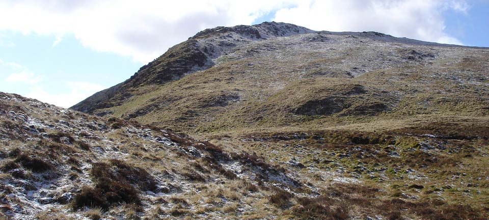
0900 to find Shalloch-on-Minnoch covered in
snow. A look north showed the clouds moving
fast towards the south with clear skies
behind. Kirriereoch and the Merrick are
just to the left in this image at the south
end of this range.
|

|
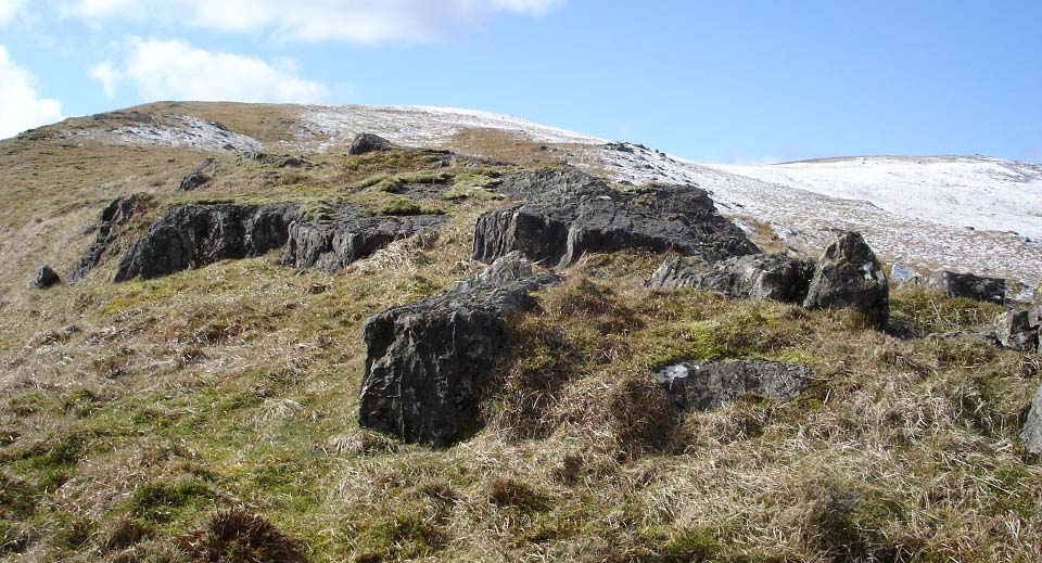
The weather began clearing quick so made
plans for the north route. The east side is
real steep, but has one route up without
scrambling?
I planned to make my way up onto the
rocky ridge at the clearing, as can be seen
on the photo below, walk along the rocky
ridge, then onto the snow covered north
side of Shalloch-on-Minnoch.
|

|
About one third of a mile back along the
road, I took the forest road down the side
of the loch marked for the Tunskeen
Bothy.
|

|
As soon as I reached the clearing in the
forest, I began hiking up to the top of the
rocky ridge. This is cleared woodland with
no trails so is a bit testing. This takes
you up to between Shiel Hill and
Craigmasheenie.
|

|
The top of the rocky ridge gives good
views northwest as seen below.
If you walk out from the car park at the
Stinchar Bridge, that trail will bring you
to the 1,532ft Cornish Hill and Cornish
Loch as seen below. The 1,666ft Shiel Hill
is to the right in this image. You have to
scross a narrow burn at Cornish Loch to get
to Shiel Hill, and the Trig Point on Shiel
Hill sits on a lump of granite sticking out
the top of the hill. It is a fair hike up
from Cornish Loch through heather to Shiel
hill, following faint animal tracks. Hiking
round to Shalloch-on-Minnoch along the
ridge from Shiel Hill is fairly good going,
with a bit of rock hopping here and
there.
|

|
The view across from the ridge at Shiel
Hill to the the 1,768ft Craigmasheenie
revealed a fair hike down and back up again
was required.
|

|
Approaching the top of Craigmasheenie,
was good hiking with large boulders
everywhere and a few good height drops here
and there.
|

|
The top of Craigmasheenie gave a good
view of the north side of
Shalloch-on-Minnoch.
|

|
Between Craigmasheenie and
Shalloch-on-Minnoch is a deeper drop than
it looked from the car park, so much for
the easy route to the top. I wanted to hike
up the ridge for the good views over the
lochs but noticed some cliffs on that
route. I decided to head right in this
image then over onto the ridge when above
the cliffs.
This route up certainly is the most
testing, and gives the sense you are hiking
up a real testing mountain.
|

|
Below is the start of the east
ridge.
|
|
By the time I reached the ridge, the
snow was disappearing fast. You can see the
route I took from the top of Loch Riecawr
on the right, up through the clearing, then
along the rocky ridge onto this
mountain.
|

|
The hike up the east ridge was just what
I expected with great views all around.
Note the top of this mountain is over to
the right on the west side.
There is a spot up this ridge that the
wind blows through real hard, so be
careful.
|
|
Close to the top of the east ridge is a
great place for photos. Loch Riecawr is in
the middle of this photo and Loch Doon
higher to the right. Loch Doon runs for
miles, almost to the left side of this
photo.
Large
Image
|

|
The view south from the east ridge shows
the highest mountains in the neighbouring
county of Dumfries & Galloway. The
border between the counties of Ayrshire and
Galloway runs across this area, just south
of Shalloch-on-Minnoch.
|

|
The top of the east ridge is marked by a
pile of stones. The white Trig Point stone
and cairn a few hundred yards west is
supposed to mark the top of the mountain,
and the cairn about 100 yards north of
that, is supposed to mark the highest
point.
|

|
The view south from here gives a good
view of the Galloway mountains with the
highest being the Merrick at 2,766ft, and
the one in front of that being the 2,579ft
Kirriereoch. The Merrick is the highest
mountain in southern Scotland. Would have
liked to have hiked the three of these but
would have been a long day. The north side
of Kirriereoch is real steep, but straight
forward enough up through boulders. From
Kirriereoch to the The Merrick is fairly
easy, as long as there is no snow and
ice.
Large
Image
|

|
The view west from the cairn shows the
wind farm on the Hadyard Hills, then beyond
that the Firth of Clyde with the Island of
Ailsa Craig just left of the stone, the
Mull of Kintyre beyond that and the Isle of
Arran to the north. Large
Image.
|

|
Below is the view south towards the
Merrick. Large
Image.
|

|
I decided to take the short route back
down between Shalloch-on-Minnoch and
Craigmasheenie, then down the east side,
followng the ridge to the left in this
image down.
|

|
The view below is from the Tunskeen
Bothy forest road showing this is the more
direct route by following the road right to
here. There is one steep route up here that
does not require scrambling, but is real
steep.
|

|
Its about a two mile walk back to the
car park at Loch Riecawr from Shalloch on
Minnoch. The image below is looking back
from the Tunskeen Bothy forest road. This
is the best road in the park with plenty of
passing places, not sure if you are allowed
to drive down this road to the Tunskeen
Bothy.
|

|
The forest road in the image above,
heading south, leads to the Tunskeen Bothy
at the south side of Shalloch-on-Minnoch,
just north of the2,579 ft Kirriereoch and
the 2,766ft Merrick.
The image below is by Rick Heath from
the steep northeast face of Kirriereoch
looking at the south side of
Shalloch-on-Minoch, when his party were
doing the three 2,500 ft + mountains here
from the Tunskeen Bothy.
More images of the Tunskeen Bothy and
the Climb by the Rick Heath
Party.
|

|
The hike took me about six hours
including the walk through the forest road.
I had to hang about a few times waiting for
the clouds to roll over so as to get sunny
photos, this added some time to the
trip.
The hike was a bit soggy on the lower
part of the north side, probably due to the
snow melting.
Getting dropped off at the large passing
place 1 third of a mile south of the
Stinchar Bridge, hiking across Cairnadloch,
Caeloch Dhu, Shalloch-on-Minnoch,
Tarfessock, Kirriereoch, Little Spear, The
Merrick, Benyellary then down to Loch Trool
to be picked up at the Buce's Stone car
park is a good hike along the Merrick
Range, taking between 6 and 9 hours.
Large Route
Map . Short
Video
Shalloch-on-Minnoch easy Route
from Stinchar Bridge.
The Merrick
Tour
Kirriereoch
Tour
|
|
|